


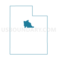
Pleasant Grove 1 Part C Voting District, Utah County, Utah
About
Outline

Summary
| Unique Area Identifier | 680253 |
| Name | Pleasant Grove 1 Part C Voting District |
| County | Utah County |
| State | Utah |
| Area (square miles) | 0.00 |
| Land Area (square miles) | 0.00 |
| Water Area (square miles) | 0.00 |
| % of Land Area | 100.00 |
| % of Water Area | 0.00 |
| Latitude of the Internal Point | 40.38538580 |
| Longtitude of the Internal Point | -111.77208450 |
Maps


Graphs
Select a template below for downloading or customizing gragh for Pleasant Grove 1 Part C Voting District, Utah County, Utah


Neighbors
Neighoring Voting District (by Name) Neighboring Voting District on the Map
- American Fork 10 Part A Voting District, Utah County, UT
- American Fork 10 Split Part B Voting District, Utah County, UT
- American Fork 10 Split Part D Voting District, Utah County, UT
- American Fork 7 Voting District, Utah County, UT